
How to do a Zoning Analysis, Part 1
Get out your calculator!

Last week, I wrote a post about the basics of what Zoning is. But...how do you actually use it? Read it? Understand how it affects your project, your ideas, and your proforma?
As usual, the answer is more complicated than we'd all like it to be. For starters, every jurisdiction is completely different - zoning is written and administered by local city or town government. So what is allowed in one town is not only completely different than what's allowed in a neighboring town, the whole entire *process* is different.
That said, there are some basics that are relatively similar, no matter where you're working. Master the principles of these basics, and you'll be well on your way to understanding zoning anywhere you're working.
This is Part 1 - as I was writing, things got long - so stay tuned for Part 2 next week!
This article assumes you've got a baseline understanding of what zoning is and what it does. If you'd like a more basic overview, check out this post here.
For the purposes of illustration, I’ll use the zoning ordinance from Cambridge, MA, which is one I know quite well, and which has many elements of zoning code common to many jurisdictions.
Ok, let's dive in.
1. Look up your zoning ordinance.
They're almost always posted online, and can be found by googling "[your town] zoning" - way easier than wading through cumbersome local government websites. Browse through it. Zoning ordinances are usually set up with an intro chapter explaining when the code was written and by whom, and a chapter with a series of definitions.
For now, just skim and peruse. You'll see stuff about allowed uses, tables showing dimensional requirements, information on how to pursue various procedures [variances, special permits, site plan reviews, design reviews, etc], sections on special districts [historic, economic development areas, etc] and the like. Get a feel for which sections might matter more to you - if you're a homeowner, you can skip all the commercial/industrial/institutional stuff, for example.
Here is Cambridge’s landing page for their zoning ordinance, where you can click on each chapter to learn more. The ones I use most are chapters 2, 4, 5, 6, 8, but over the spread of our projects, I use all of them to some extent. Notice some other helpful stuff - contact info, hours, and a link to recent amendments.

In Cambridge, one of the most helpful things they do is have “office hours” at the building department, where you can go in and talk to any inspector who’s available. While they can’t always give precise answers because projects/contexts vary so much, you can almost always get a nugget of information or help that moves your project forward. If your building department has this resource - USE IT!! Most building departments won’t let you talk to anyone. This, in my mind, is one of the absolute best/most important things a city could do to make things easier for both homeowners and business people trying to get stuff built.
The other thing to note is the link to recent amendments. Ordinances are always evolving and changing, and the most recent changes might not be reflected in the full document. In Cambridge, for instance, there was an amendment passed that was *incredibly* helpful to homeowners and small developers, and made a ton of projects viable by removing an onerous zoning requirement. If you didn’t look up the recent amendments, you would miss that - and miss a huge opportunity.
2. Figure out which sections of the zoning ordinance pertain to your project.
Included within the ordinance should be a map, showing every single parcel in the jurisdiction. Find your lot, and notice which district or zone it's in. That district or zone will tell you which rules apply to you on this lot.
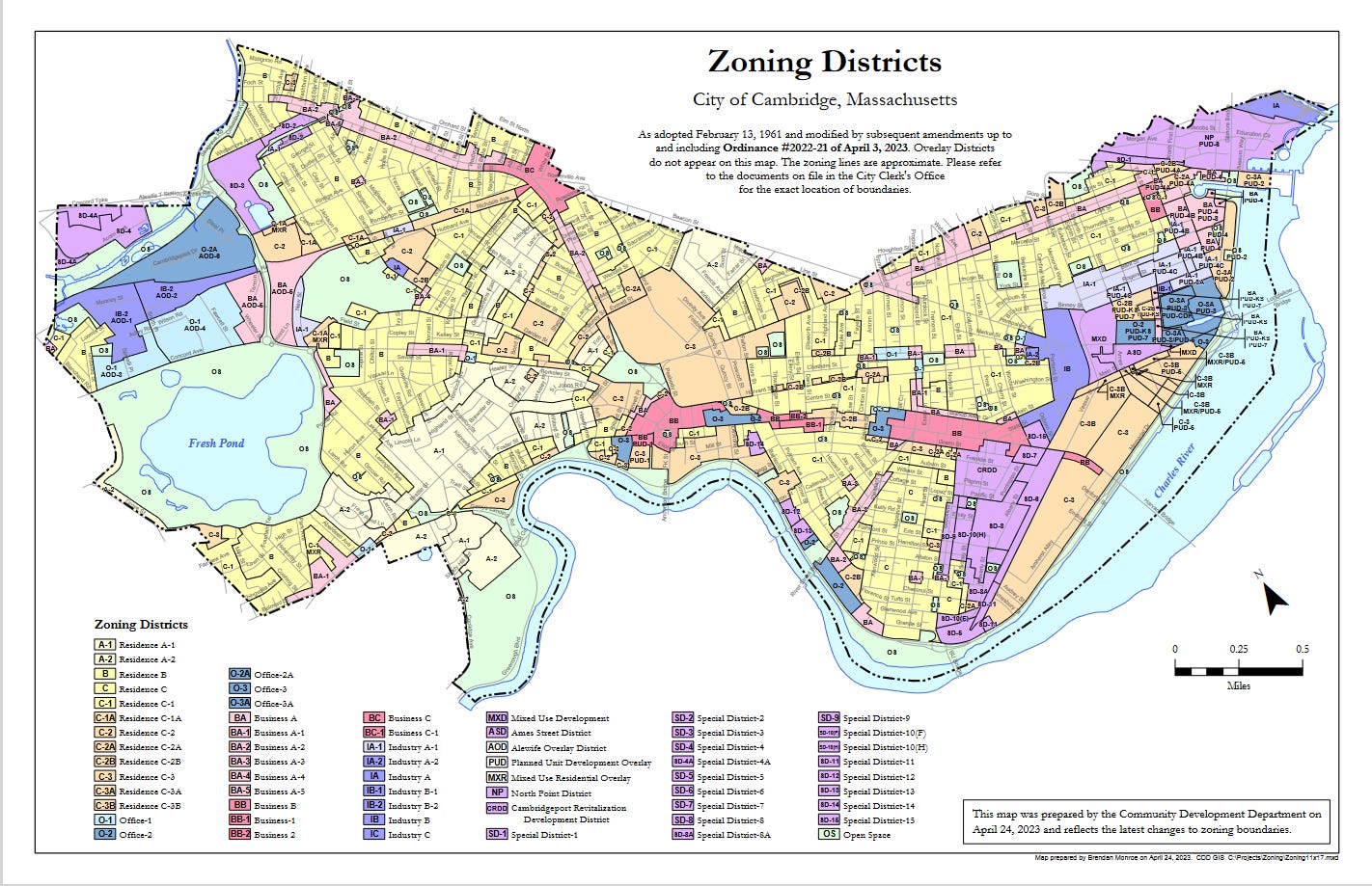
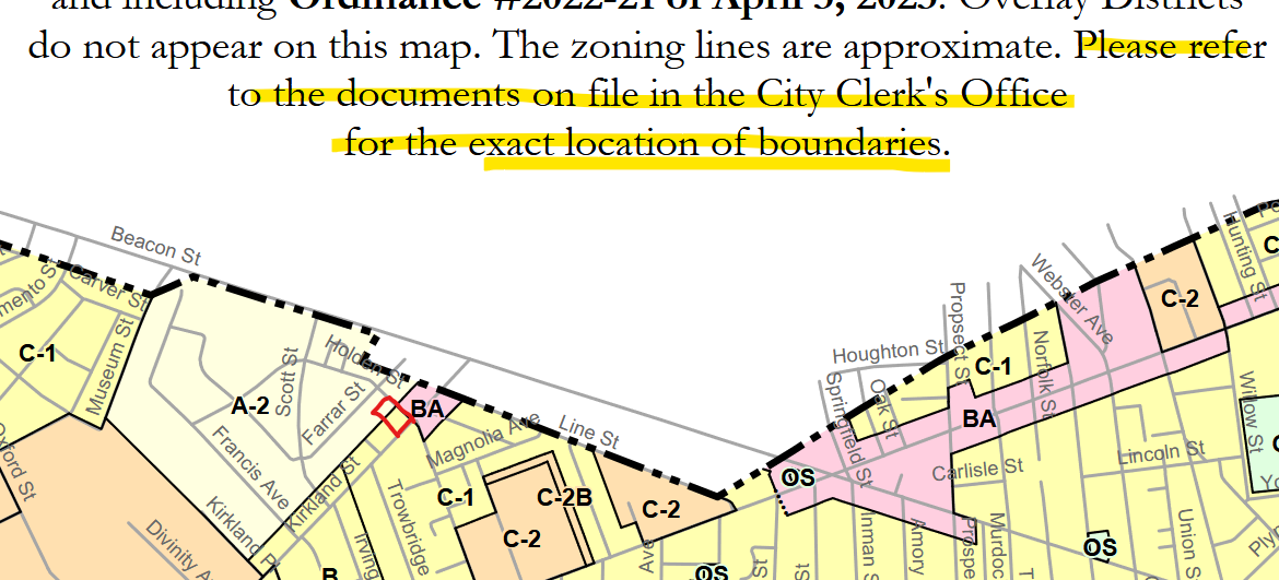
Note that even neighboring parcels might have different rules - and that a zoning line may even go *through* your property! [That happened to us on a project - whew - lots of extra calculations!]
The red square, below, is where that project was located. Looking on the map, we thought it was fully in the C-1 district. But, having learned my lesson before, whenever a parcel is bordering another district, I go in to the Clerk’s Office and look at the official maps…lo and behold, the back portion of this parcel was in the A-2 district. It didn’t kill the project, but it made it more difficult. It *would* have killed the project if we hadn’t found it ahead of time - all our analysis would be wrong, and the city would’ve kicked it into a variance process, which the owner didn’t want. Better to know as much ahead of time as possible - you don’t want the city finding stuff you didn’t already know about!
3. Carefully read the dimensional table pertaining to your project.
Now that you know which rules apply to your parcel, review the dimensional tables. This is where you'll learn what the setbacks, FAR, height, lot size, green space, parking, number of units, etc requirements and limitations are. Here's an excerpt from Cambridge's tables, for every district:
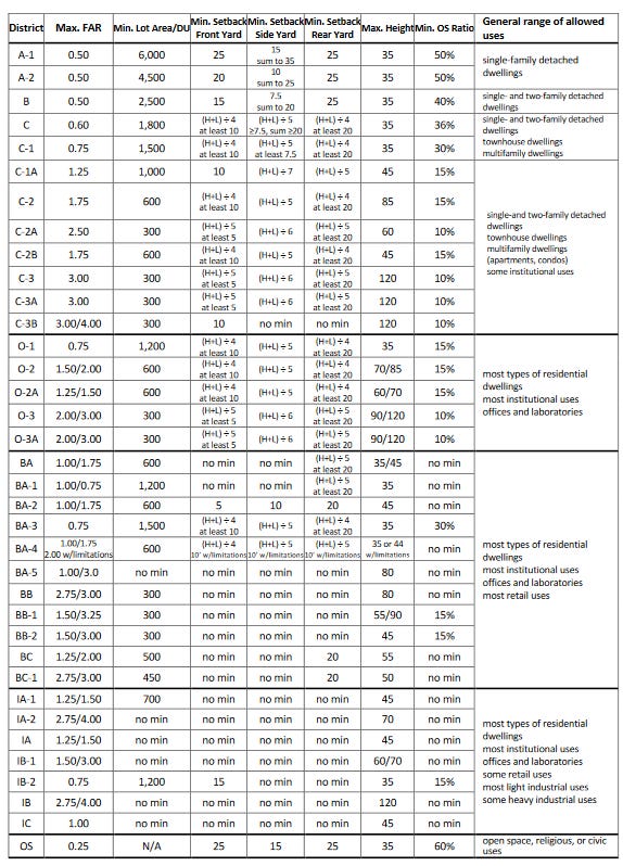
Take a look at C-1 - note that the “side setback” is a calculation, a relationship between height and length of the building.

This means that you have to look up the definition of “height” and “length” and show those calculations exactly how the city wants to see them. [Hint - they’re not straightforward! This is where I see a lot of folks get tripped up - you need to work with the definitions of “height” and “story” and “finished floor area” and whatnot *as defined by your jurisdiction* - not as defined by you, Webster, or even common sense.] Go back to the chapter in your ordinance that defines every term, and use that.
Here’s a height calculation for a project in Cambridge, as an example. Note that we had to include the depth of the areaway stair and basement egress window well as part of the height calculation.
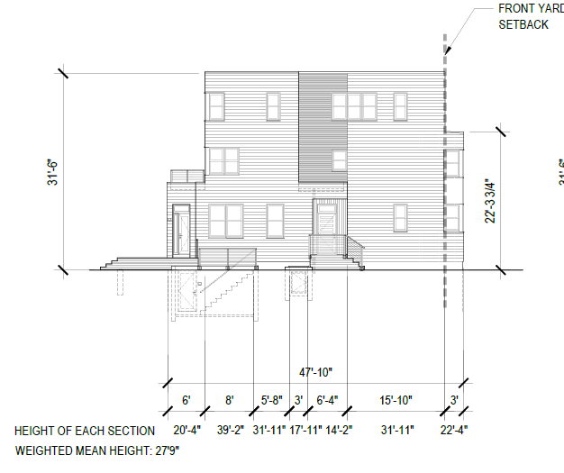
But wait, there’s more! The chart above is just a cheat sheet - if you carefully read the ordinance, you’ll see a footnote that leads you to this provision, which allows an increased denominator on buildings shorter than 40’ - score!! That means I can decrease my side yard and fit more building on the site, as long as a meet the additional requirements in several more footnotes.

Is your head spinning yet?? The wild part is, this is just *one* small element of the zoning dimensional requirements. The same level of care needs to be taken for every other required calculation, as well.
Sidenote - you may be asking yourself, is my jurisdiction this complicated? I can’t answer that - other than to say, even in smaller towns or places with less strict requirements, there are still quirks and specifics to zoning that need to be taken into consideration. Even if you don’t have to do such complicated calculations, you’ll still have to address many of these issues in your zoning review.
4. Figure out how the jurisdiction handles nonconformities
A zoning "nonconformity" is when something on your parcel is already existing, but doesn't comply with current zoning regulations. For example, zoning may require your lot to be 50' wide, but yours is 40', or, it may only allow single family homes, but yours is a duplex, etc.
Generally, nonconformities are things you want to keep, as they are things you wouldn't be able to do under current regulations - they are "grandfathered" in. Different zoning codes treat "grandfathering" differently - some will allow you to tear down the whole building and build back exactly what was there, some will make you keep the whole entire building *and* pursue a zoning variance to move a single window on a nonconforming wall.
There may be a special section on nonconformities in your ordinance, or that information might be contained in the "definitions" section or in a "development standards" section. Regardless, this is a very important thing to understand!
In Cambridge’s ordinance, it’s chapter 8, with the most important subsection at 8.22.1. Anyone who does work on existing buildings in Cambridge has this section basically memorized, but it is still important to read it very carefully each time.
5. Get a survey
Without a survey, you can't do a real zoning analysis, especially if you're on a tight site where inches matter. That said, even on a larger parcel where you're testing multifamily or mixed use concepts, if you don't know the true boundaries, you'll be staking large financial decisions on a screen grab from Google maps. Not smart.
Surveys will also turn up stuff that impacts what you can and can't do on a lot, and that interact with zoning - stuff like easements, utility information, street location, etc. I've seen many situations where someone *thought* their property line was in a certain location, but it was actually quite different - and had a profound impact on what they could build! Whether a road is a public or private way, whether part of your building is on another lot, what the true height and dimensions of your building are…these are all things I’ve seen come up as surprises on a survey.
As you have seen so far, a lot hinges on the accuracy of the numbers and dimensions you’re basing your analysis on - your analysis will only be as accurate as the information you’re basing it on. In other words - garbage in, garbage out!
It’s why when someone asks us over the phone “what can I do on this lot,” we can’t really answer, other than generally. This stuff is tricky!
Next up, Part 2…
Ok, now that you have your stuff gathered, we're ready for Part 2, coming next week! If you're already feeling like this is a lot of work to do, think of it this way - whether you're a homeowner looking to purchase a home or do a renovation/addition, or whether you're a developer testing parcels for your next multifamily project, you're making very large financial decisions. Taking some time to make sure it's prudent is not only wise, it'll save you untold amounts of money and potential headache.
Thank you for reading, and for your support! If you think someone you know might be interested in reading Building Knowledge, won’t you share a subscription or refer them?